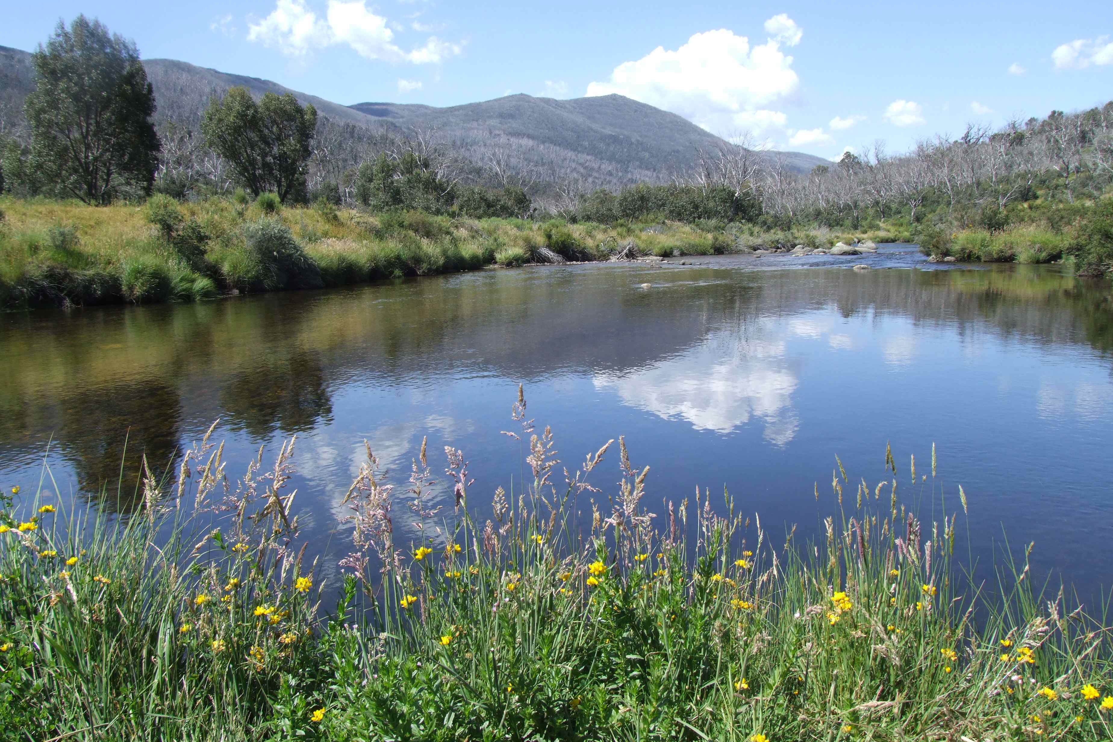
As some of you know, I am currently having a little summer break in Australia’s high country, based in Thredbo in Kosciuszko National Park. This is an annual trek for Mr Gums and me, and I have written about it occasionally before. I thought I’d do so again for this week’s Monday Musings, from an historical angle. It’s just a soupçon, because I’m too busy holidaying to do more!
Bundian Way
The Bundian Way is, says its website, “an ancient pathway for Aboriginal people from Yuin, Ngarigo, Jaitmathang, Bidawal Country that provided safe passage between the coast and the high country”.

The project to document and develop it as a community resource is an ambitious one that, say the organisers, is not about native title, but about acknowledging “Aboriginal cultural heritage values in the historic landscape” and that “these are symbolised by the old pathways”. Surveying the Way commenced in 2010, and was conducted, says Wikipedia, by the Eden Aboriginal Land Council and naturalist John Blay (who has subsequently written On track: Searching out the Bundian Way, 2015). They identified the 265-kilometre route (though the length varies a bit according to the source) using, for example, historical records like 19th century survey reports and journals. The website notes early interactions with Europeans, and the role played by journals:
The old Aboriginal people showed the European ‘explorers’ the pathways (e.g. Ryrie 1840 journals and maps; Robinson 1844-5) and permitted use of the country in the earliest days by highland Scots shepherds, and the horsemen and cattlemen who followed (Watson 1984).
I came across the Bundian Way in an article in the December 2020 issue of the free The Snowpost magazine. It describes the Way as “a shared history pathway” “that was the easiest path from the Monaro to the coastal plains”. It includes places associated with Aboriginal whaling and springtime ceremonies in Twofold Bay on the south coast, and Aboriginal bogong moth hunting and ceremonies in the high country in summer. The article notes that there is still evidence along the route of “old land management … in its Aboriginal landscapes”, which presumably was also used in the survey.
The Snowpost (possibly using Wikipedia) also notes the role played by the controversial Chief Protector of Aborigines GA Robinson in all this. Wikipedia cites John Blay as saying that Robinson recorded the story of Al.mil.gong who walked from Omeo to present his new corroboree to his kin at Bilgalera on Twofold Bay on 14 August 1844. The important thing is not who provides the information, but that we have the information, eh? The Snowpost also records that geologist WB Clarke, who explored around here in 1852, recorded Indigenous people’s description of the Bundian Pass. Unfortunately, his writings and Robinson’s don’t appear to be available on Project Gutenberg Australia.
Finally, the Snowy-Monaro Regional Council makes the point that:
This walking track is older than the silk roads and was used the Aboriginal people for trading, ceremonies, family gatherings and caring for country for thousands of years.
Georg von Neumayer

Also active in Australia around the middle of the nineteenth century, like Robinson and Clarke, was the German polar explorer and scientist Georg Neumayer or Georg Balthasar von Neumayer. Tim Flannery writes in his book, The explorers, that “the exploration of the Australian Alps seems inextricably linked with Germans and Poles: Lhotsky, Strzelecki, Neumayer and von Guérard”. Neumayer, who was interested in “terrestrial magnetism, hydrography and meteorology”, conducted a magnetic survey of “the colony of Victoria”. In doing so, he visited the summit of Mt Kosciuszko in November-December, 1862, with his assistant Edward Brinkmann and the artist Eugène von Guérard. Flannery writes that Neumayer’s account of this trip “provides a terrifying example of Australia’s fickle alpine weather”. Flannery also says that the Von Guérard painted “one of his most memorable works [of Mt Kosciuszko] from the view he obtained on that dramatic November day”. You can see a version on the Art Gallery of New South Wales website.
Flannery quotes Neumayer as saying that
The vegetation near the camping place [which overlooked the Manroo Plains and Thredbo River] reminds one very much of that of the Alps except that the strange look of the dwarf gum trees introduces rather a new feature.
I suspect it’s true that alpine regions can look very similar – except for vegetation! Neumayer also notes that
M. de Guérard, meanwhile, had seated himself on the summit, which affords a beautiful view of the mountainous country of New South Wales and Victoria, as well as the plains of the Murray River, and was taking a sketch of the scenery when, just as I was completing my observations, he called out that it appeared to him a heavy storm was approaching from the New South Wales side.
What follows is a rather terrifying description of coping with this storm, during which Edward Brinkmann (who was looking after some of Neumayer’s instruments) got lost. This was around 18 November 1962, I think. Despite looking hard for him, they could not find him.
Neumayer writes on 3 December 1862
The day very hot, and a haze, caused by bushfires, over the whole sky, so that nothing of the fine mountain scenery was visible.
Such is the alpine environment – blizzard one day, bushfire the next. Anyhow, Neumayer and von Guérard
Went to the police court, but could hear nothing of him, so that the last hope of his safety was now quite destroyed. Sat down to dinner, and had hardly done so when the lost man made his appearance in a most deplorable condition, having been without food and clothes for some time. My conjectures as to the route he had taken proved to be correct. Soon after leaving us on Mt Kosciusko, he endeavoured to return but missed the track to the camp and descended into the valley of the Thredbo River. For two days he wandered on, with scarcely anything to eat, until he fell in with some diggers in a lonely valley, who behaved most kindly to him and assisted him in making his way to Kiandra. … I cannot quit this most annoying affair without expressing my appreciation of Edward’s courageous behaviour, after separating from our party, and of the skill and care he bestowed upon the instruments entrusted to his charge; for the fine mountain barometer Fortin II did not receive the least injury during the whole of this rough and perilous journey.
I love that Neumayer seems to have cared both about Brinkmann AND his instruments!

I have been to Jindabyne in the snow season and have driven in summer from Cooma, around Kosciuszko and along the river to Wodonga (by car). It’s lovely country. My main interest of course is Miles Franklin, some of whose forebears settled in the Monaro high country. I wrote in my review of Up the Country that MF believed that the local Aboriginal people (the Ngarigo) withdrew to the coast during the winter, but that this was contested. Unfortunately the website I linked to has gone. Up the Country begins in 1852 and within a generation the Ngarigo are gone (from the story anyway).
Thanks Bill. I think the Bundian Way is recovering much of the story but the view was that they’d all but gone. BTW we drove here via Tumut … don’t usually do that … and vis Talbingo but of course her g’parents’ home was destroyed by the scheme!
And that he found the affair “annoying” !! 😀
Lovely stuff, ST.
Go back to relaxing, please !!!
Thanks M-R! I will do my best though it’s homeward bound today.
I went to an author event featuring Van Guerard a year or so ago: he was a fascinating man.
If you have idle moments while on holiday you might enjoy my post about it: https://anzlitlovers.com/2018/04/06/the-artist-as-traveller-the-sketchbooks-of-eugene-von-guerard-by-ruth-pullin-author-event/
Oh thanks Lisa … I’ll check that out as I know little about him,
Hope you’re feeling rested and relaxed after your holiday, Sue. I went on a school trip to Jindabyne years ago, can remember running down Mt Kosciuszko after climbing up via the path, sailing the lake on a catamaran and going cross-country with a compass. No idea where I went, despite holding the compass the whole way!
Haha, Rose, that makes me laugh. It’s interesting what you don’t notice when you are young!
The catamaran would have been on Lake Jindabyne I presume, but how you got to Mt Kosciuszko will depend on how long ago we are talking about. These days, you would get the chairlift up to Eagle’s Nest from Thredbo, and then do the 13km return walk. That’s a long walk for school kids? (There are longer routes from Charlotte Pass but I don’t imagine you did that.) The thing is that before my time – which is not to say that you are older than I am but that my first trip to Kosciuszko wasn’t until the 1990s – you could drive closer to Mt Kosciuszko from Charlotte Pass. Mr Gums did this as a child because he grew up in Canberra. In fact, I *think* from where you could leave your vehicle back then to the peak was only about 1.5 km one way so 3 km return, but I don’t know when that road was closed to tourist traffic. We have walked it some of it from Charlotte Pass, because it’s now a (gravel) service road and walking path but not a tourist road.
I have no idea where you went cross-country with a compass!! That could have been anywhere!!
Anyhow, it was a lovely relaxing holiday because we didn’t push ourselves hard, but did do some nice walks.
I can go back further. In the late ’50s you could drive right to the top of Kosciuszko. Only in summer, of course. Somewhere there are photos showing the family at the top. I vaguely recall that the trip included my grandmother, but I could be wrong.
Now I’m cranky with my father. We drove up the Cann Valley Hwy more than once in the 1950s to visit his parents in Canberra and we DIDN’T drive up Mt Kosciuszko. Did walk around Adiminiby before it was drowned though.
Naughty father! You missed a great opportunity. Did you see Miles’ grandparents place before it drowned, which is more to the point?
Thanks Neil! I’m glad people have to work for it now! I must ask Mr Gums … he has told me but maybe he and his family drove right to the top too.
I don’t remember Talbingo. But I was only 5!
I’ll let you off then. I don’t remember much from when I was 5 either!
The catamaran was on Lake Jindabyne and the experience was lovely. I remember laying on the canvas at one stage and looking at the sky.
The walk up Mt K was quite long but was also gentle and if I remember correctly there was a path. We took a short cut down and rolled down a grassy patch near the bottom. It was around 1985, I think. Back then I don’t think a 13km walk was considered too much for a school group. I expect if something had gone wrong one of the teachers would have walked back to the bus to ask for the bus driver’s help, since this was long before mobile phones and the like. My parents probably signed something to say I could go and that was it.
Glad you had a good holiday and got some walks in.
Sounds like you did the real walk then but did you go up the chairlift. If you didn’t then I don’t know where you started the walk from. Anyhow, there is a decent path now and it’s not steep or rough so you probably did that.
No, I don’t remember the chair lift. We were probably dropped off somewhere by the school bus 🙂
Welll that means you must have walked from Charlotte Pass end which is 18km round trip. It’s 13km from top on chairlift. Not a difficult walk but long!
Thredbo and the High Country is such a beautiful place. For it’s all about Elyne Mitchell’s Silver Brumby books, of course! I climbed Mt K at age 12, walking from the top of the chairlift. Dad and I meant only to go as far as the lookout but we missed the sign, kept walking and by the time we realised, we were so close to to Mt K we thought we might as well go right up. I remember it as a vey easy walk. I did it again 15 years later and it seemed much harder! Didn’t spot a brumby either time, though. Sigh.
Sorry – typo. For ME, it’s all about…
My daughter loved those books Michelle. We have seen brumbies but in the 20 plus years we’ve been going I could count on one hand the number of sightings. The most memorable was on a walk called Bob’s Ridge because there were a few of them and we were walking so we got to see them properly.
The thing about the Mt K walk is that it’s all above the treeline so there’s no shade. You want a coolish day but not a cold blowy one!