A couple of years ago I wrote three Let’s get physical posts in which I focused on physical descriptions of places in Australia. Since, I am currently in Central Australia (for my third time), I thought it would be good to write another post or two in this series. Central Australia – or the Alice Springs Region, or the Alice-MacDonnell Ranges area – comprises the southern part of the Northern Territory, and includes the famous sites of Uluru and Kata Tjuta.
Alice Springs, itself, is the second major city in the Northern Territory, after the capital, Darwin. My introduction to the Alice was through Nevil Shute’s novel A town like Alice, but but in fact very little of the book is set in Alice Springs. Eleanor Hogan author of Alice Springs in New South’s Cities series said recently in a Wheeler centre interview:
I was particularly interested in the idea of Alice as a microcosm of national identity and history. It’s not a metaphor that you can take to literal extremes, but there are plenty of conundrums and paradoxes about life in Alice as the premier outback town at the heart of the country that intrigued me.
Central Australia is the quintessential outback. It’s geologically old – very flat with low mountain ranges which were formed 350-300 million years ago – and the earth is red. Population is sparse and distances great. It’s replete with heroes and “characters” like explorer-prospector Lasseter, missionary and Flying Doctor Service founder John Flynn, anthropoligist Ted Strehlow, and indigenous artist Albert Namatjira. It has been criss-crossed by many explorers, and it is where Robyn Davidson started her across-desert trek with camels, chronicled in her book (and the later film), Tracks. And it is, most importantly, home to large communities of indigenous people, who, according to Wikipedia, make up about 50% of the region’s population.
Since my focus here is the physical, though, I won’t go further into the history (or we’ll be here all day). The most famous (white) explorer of colonial Australia in this region was John McDouall Stuart, whose south-north expeditions resulted in the establishment of the Australian Overland Telegraph Line and of the main route from Port Augusta to Darwin (now known as the Stuart Highway). Stuart’s journals (covering 1858 to 1862) are available at Project Gutenberg Australia. I’ll share a couple of excerpts from the Journal of Mr Stuart’s fourth expedition – fixing the centre of the continent. From March to September, 1860. These entries describe the landscape a little south of the Alice:
At eight miles the red sand hills commence, covered with spinifex; and on the small flats mulga scrub, which continues to the base of the hill. Red loose sand; no water (Tuesday, 3 April)
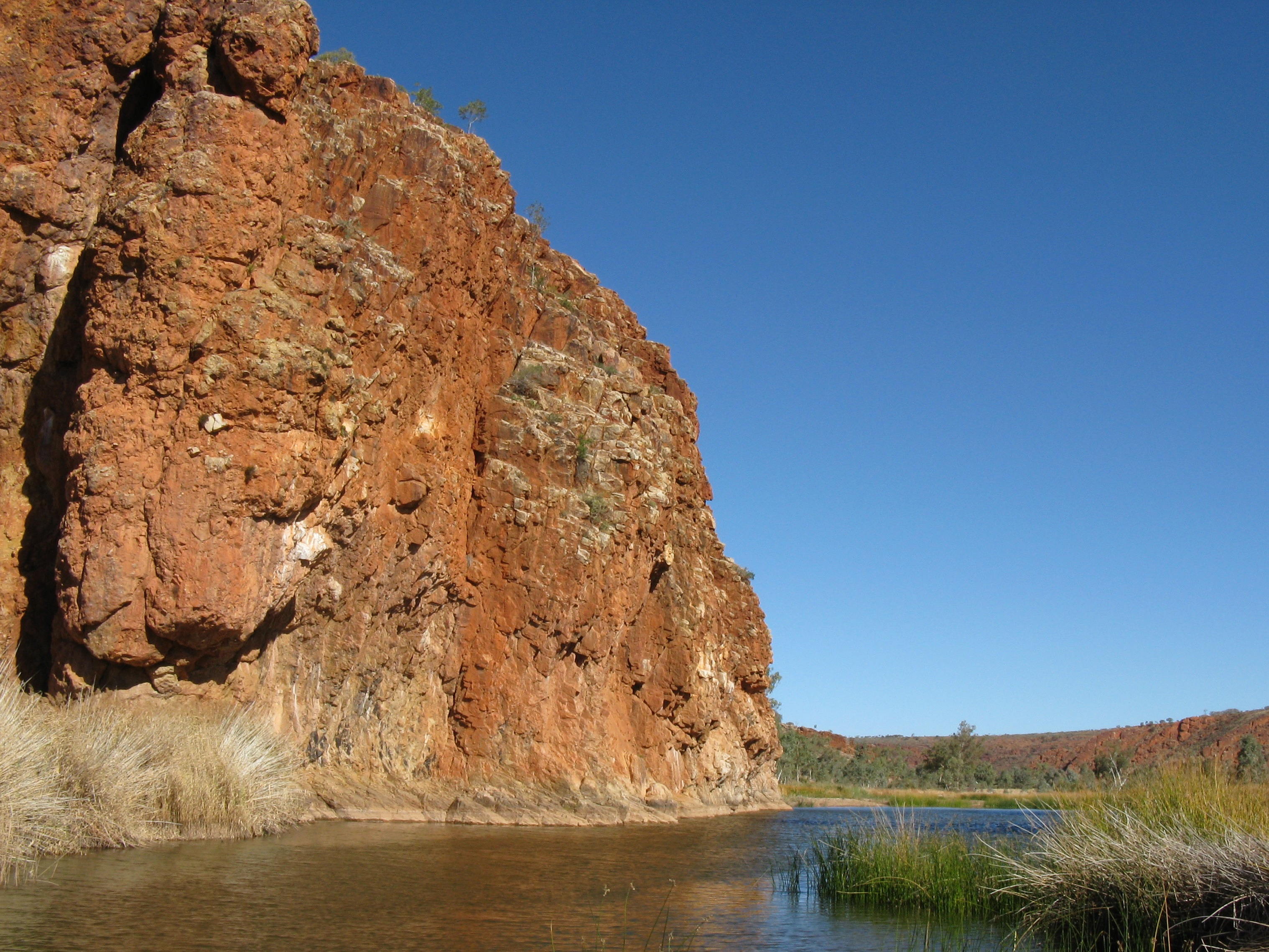
Finke River, Glen Helen Gorge, West MacDonnells
The creek is very large, with the finest gum-trees we have yet seen, all sizes and heights. This seems to be a favourite place for the natives to camp, as there are eleven worleys in one encampment. We saw here a number of new parrots, the black cockatoo, and numerous other birds. The creek runs over a space of about two miles, coming from the west; the bed sandy. After leaving it … we passed over a plain of as fine a country as any man would wish to see–a beautiful red soil covered with grass a foot high; after that it becomes a little sandy. At fifteen miles we got into some sand hills, but the feed was still most abundant. I have not passed through such splendid country since I have been in the colony. I only hope it may continue. The creek I have named the Finke, after William Finke, Esquire, of Adelaide, my sincere and tried friend … (Wednesday 4 April)
It was he who “named” the MacDonnell Ranges. His journals are beautiful in their description of the geology, plants and fauna of the region. He also notes the presence of local indigenous people (either by seeing them or their tracks or campsites).

Uluru – what more can you say. Ancient and sublime!
A little later came Ernest Giles, who “named” Mount Olga (now returned to the indigenous name of Kata Tjuta). The following comes from his Australia twice traversed:
Its appearance [Ayers Rock, now Uluru] and outline is most imposing, for it is simply a mammoth monolith that rises out of the sandy desert soil around, and stands with a perpendicular and totally inaccessible face at all points, except one slope near the north-west end, and that at least is but a precarious climbing ground to a height of more than 1100 feet. Down its furrowed and corrugated sides the trickling of water for untold ages has descended in times of rain, and for long periods after, until the drainage ceased, into sandy basins at its feet. The dimensions of this vast slab are over two miles long, over one mile through, and nearly a quarter of a mile high. The great difference between it and Mount Olga [now Kata Tjuta] is in the rock formation, for this is one solid granite stone, and is part and parcel of the original rock, which, having been formed after its state of fusion in the beginning, has there remained, while the aged Mount Olga has been thrown up subsequently from below. Mount Olga is the more wonderful and grotesque; Mount Ayers the more ancient and sublime. (July 1874)
And now, something written by an indigenous woman from a book titled Women of the centre (edited by Adele Pring, 1990). The story-teller is Ruth Mackenzie (b. 1919), an Aranda/Aluritja woman, born just south of the Northern Territory border. This particular description is of country a little further south again, but is still relevant. I’m including it because she’s describing traditional Aboriginal knowledge:
He [husband] told us stories … All this country was jungle. That’s a long way back and there used to be big snakes but the seasons changed. Drought and that came and buried everything up and what they call Yandama sandhills the other side of Lake Frome – all those sandhills – that’s all the trees that’s covered up. I think they’ve found animals there. Animals were bigger – wombat, kangaroo. Everything was a lot larger than what they are now. That’s what he said. Australia was different from what it is now, like it’s all barren country now. It was like Darwin I suppose.
For those of you inspired to read about the region, the following books may be of interest:
- Robyn Davidson‘s Tracks (1980)
- Ernestine Hill‘s The territory (1951)
- Ion Idriess‘s Flynn of the Inland (1932)
Many more books are listed on Wikipedia’s Australian outback literature of the 20th century page.
The majority of Australians live on the coast and are drawn to the sea. Not me. I am drawn to the deserts and the Outback. Maybe this post has explained why?
Note: An excellent discussion of “literary constructions” about the Centre can be found in Chapter 8 of The Cultural Values of the Central Ranges: a preliminary report (for the region’s inclusion as a World Heritage area) (2008).
.
